THE MONASTERY OF SAINT GEORGE OF GOMS
Surb Gomki Georgi Vank
History
The monastery is not mentioned in any known historical source. However J. M. Thierry considers that both the design of the church and historical events indicate that the church was probably built just after the conquest of this district, called Kardchkan in Armenian, by Gagik Artsruni, the king of Vaspurakan, in 905AD.
The head of the monastery was, by tradition, the bishop of Kardchkan - which suggests that the monastery was once the most important in the district. After the Armenian king Senekerim ceded his kingdom of Vaspurakan to the Byzantine empire in 1022, the empire produced a list of the regions Bishopric seats; one such seat was at a monastery of Saint George - this could perhaps have been Goms. The monks possessed a relic that they claimed to be the head of Saint George, and for this reason the monastery was an important pilgrimage site. The local Armenian peasants called it Jojgluvank (Monastery of the Great Head). Goms, meaning "cowsheds", was the name of the nearest village to the monastery: this village is now called Kümüs by its Kurdish inhabitants, its official name is Çanakdüzü. Due to increasing Kurdish violence, in 1830 the monks had to abandon the monastery and move to a more secure location in the village of Goms. There was an unsuccessful attempt to return to the monastery at the end of the 19th century. The isolated location of the monastery has helped to maintain its preservation, but considerable damage has occurred since the early 1970s. In addition, the rising waters of lake Van during the 1990s have eroded the coastline within the bay and now menace the base of the monastery's fortified wall. Site Description
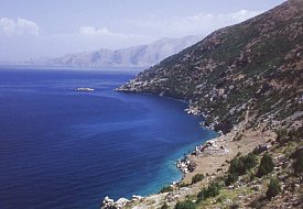
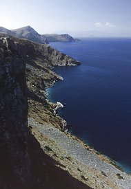
At the northern edge of Göllü Ovasi (see the bottom of this page) a steep track runs up to the summit of the lowest part of the ridge overlooking Lake Van. This track then descends to the east, at a more relaxed angle, ending at the walls of the monastery of Saint George.
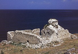
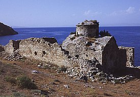
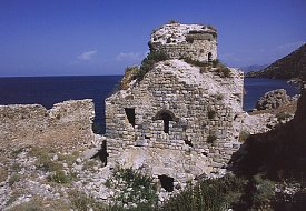
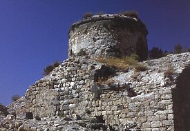
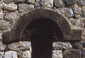
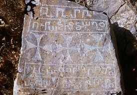
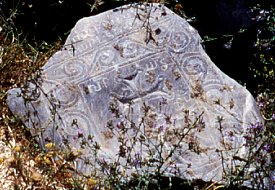
The monastery lies beside the shores of lake Van, within a compact and almost square fortified enclosure. The masonry of the enclosure wall is not bonded into the structure of the church, implying that it is a later construction and the church was originally free-standing. There are oval shaped defensive towers at the south-east and north-east corners of the wall. The wall's masonry shows two distinct layers: the bottom three quarters was constructed using roughly shaped but regularly laid stone blocks, the top third uses larger and less regularly shaped stones. Thierry noted an inscription that was inserted high in the south wall, bearing the date 1760. It said "Remember us in Christ, the sinners Ter Basil and the monk Lazare who had this wall (re)built". There are other inscribed stones in the wall: some are still in-situ, some have fallen and are lying on the ground.
There is a graveyard site to the south of the monastery wall, as well as traces of levelled and formerly cultivated land to the west.
The entrance to the enclosure was at the northern end of its east wall. This entrance is now destroyed, but Thierry saw it when it was intact and noted a small window above the entrance. This suggests that the doorway gave access directly into a room, rather than an open courtyard. Monastic buildings seem to have filled most of the space inside the walls, but these buildings are now reduced to low foundations.
Design Analysis
The church is constructed mostly from roughly squared stone blocks of schist. However, visually important parts of the church were more carefully finished using blocks of black tufa stone: these included cornices, window arches, and roofing slabs. Inside, the rough masonry of the lower walls was hidden behind a thick coating of white plaster. All of the interior above the cornice level - the dome, drum, squinches, ceiling vaults, and arches - was faced with carefully cut tufa stone.
The church has a single entrance in the west facade. It is a simple rectangular opening, with a plain lintel carved from a thick block of white stone. The lintel bears crudely hammered inscriptions, but they all seem to be from a much later date. The doorway is now so clogged with earth and rubble that it is necessary to crawl under the lintel to enter the church.
The altar apse was raised above the floor level of the nave. Corner chambers on two floors flank the altar apse. The upper chambers were entered, probably using a ladder, through rectangular openings inserted high up in the east walls of the north and south arms. There are also upper chambers at the north west and south west corners - these were entered through rectangular openings in the external facade. |
|
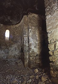 12. Inside the church, the altar apse - click for a larger photo |
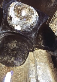 13. Looking up at the drum and dome - click for a larger photo |
 14. Squinches support the drum - click for a larger photo |
 15. A panoramic view of Göllü Ovasi, looking south, seen from the top of the ridge with the track to the monastery |
Göllü Ovasi
The valley of Goms or Kümüs, called Göllü Ovasi - the "plain with the lake", is an unusual geological feature. It is a perfectly flat, fan-shaped valley, encircled by hills. The plain is separated from lake Van only by a long, curving ridge.
Historically, in spring, when the snows melted, the plain became a shallow lake until natural tunnels that ran through the ridge let the waters escaped into lake Van. Around the edge of the plain and above the flood level are a string of villages: until 1915 most were Armenian, and at least two still contain late medieval churches. Click here to read H. F. B. Lynch's description of this valley in the 1890s. |
|