Location
55 kilometres to the southwest of the town of Kars is a large village named Tunçkaya. Its older name is Gechivan and it is built on the site of the medieval Armenian town of Ketchivan which was also known as Ketchror.
History
Nothing is known about the early history of Ketchivan. Thierry ¹ erroneously identifies Ketchivan as the Armenian town of Artagers. However, Artagers is actually the site known as Handut, located near the village of Kuloğlu, to the west of Kağızman.
During the early 13th century Ketchivan and its surrounding lands fell into the hands of a group of fanatical Muslims who severely persecuted the Armenian population. According to the medieval historian Vardan, the Muslim emir of Ketchivan plundered the nearby monastery of Karak'ar, smashing an important icon known as the "Cross of Goroz" and then, for his amusement, killing five notable monks. The bodies of the martyred monks were buried at Khtzkonk monastery, next to the chapel of St. Stephanos.
Vardan also relates that the emir of Ketchivan later became terror stricken after experiencing a vision in which saw a fearsome man saying "I am the Cross of Goroz which you broke up; behold, I shall kill you by the hands of your friend Shah-i-Armen" ². After having this vision, the emir fled Ketchivan with his family and travelled to the city of Dvin, where the Shah lived. On telling him the story, Shah-i-Armen immediately struck him through the heart with a dagger.
Most of the current inhabitants of Tunçkaya identify themselves as being ethnically Turkish; all of the surrounding villages are almost exclusively Kurdish. The population was also Turkish during the Russian period, suggesting that the present population might be descended from part of the medieval population.
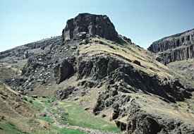
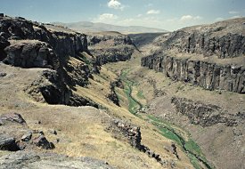
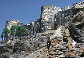
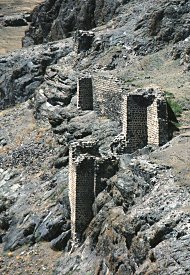
The physical appearance of the site is similar to that of Ani. Like Ani, it occupies a roughly triangular plateau between the near vertical sides of converging ravines, and has a very strong defensive wall, with u-shaped towers, that bars the only easily approachable side.
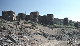
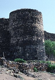
The most powerful defences are at the western end of the site, where a wall runs between the two valleys, the Buyuk Dere to the north and the Çiçekli Dere to the south. This wall is high and has five u-shaped towers. The overall effect has a visual similarity to the walls of Ani. Differences, however, include the absence of any crenellations and the lower quality of the masonry. The masonry used at Gechivan is roughly hacked blocks of stone and is very consistent in appearance, indicating that most of the walls were probably built during a single period of construction. None of the fortifications have surviving inscriptions or decorative features.
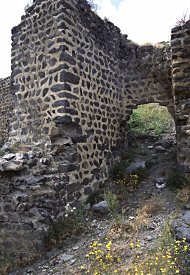
An outer defensive structure or barbican stands in front of the western wall, and in front of it there is a deep ditch. The barbican is a rectangular enclosure - most of its western end does not survive, but presumably it contained a gateway. The barbican's east wall is still relatively complete and contains an arched gateway flanked by two towers. Walls once connected the northeast and southeast corners of the barbican to the city wall.
Nothing of the gateway in the western wall survives: it is now just a gap in the wall between two towers, The gateway used to have a set of iron doors - they were still there in the 1870s when they were recorded as having crosses on them. These doors must have survived until relatively recently because older villagers still remember them being closed every night so that everyone could sleep peacefully.
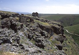
The cliffs on the northern side of the site are almost vertical. Because of this, the walls on that side of the city were probably insubstantial and almost nothing now survives. The slope on the southern side of the site is less consistently steep and is defended by a wall located about half way down the slope. The towers on this wall are rectangular. There is a postern gate within the wall, in front of which is a small enclosure that seems to be from a later period than the gate itself.
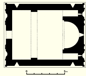
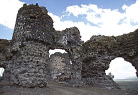
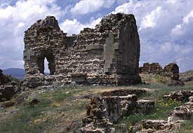
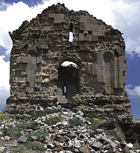
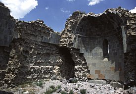
At the eastern end of the site is isolated from the rest by a break in the plateau. This section of the medieval city appears to have been independently fortified. Located within the fortifications are the ruins of a church and the foundations of several unidentified structures.
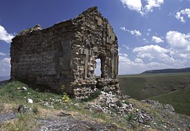
The church is a small structure; rectangular in plan, with a single-nave flanked by rectangular corner chambers. The roof has fallen, but enough remains to indicate that it had a barrel vault reinforced by a single rib-arch. The entrance was in the west façade. The internal floor level would have been at least a metre above the ground level - perhaps there was once a staircase up to the entrance. The interior was lit by a window in the apse and another in the west wall, above the entrance. The church had a lower level in the form of a vaulted crypt.
Most of the facing stones have been removed from the exterior of the church. The villagers say that soldiers did this damage in the 1940s, when they removed the stone to build a military post. Sinclair wrote that the stones were removed in c1941-42, using fire. There are some sculptural fragments from the church built into the walls of several buildings in the village.
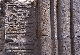
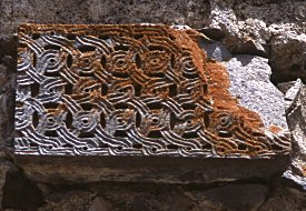
Although the surviving fragments of in-situ sculpture on the west façade are now limited to only a few blocks of stone, enough remains to reveal that it was once richly decorated. The entrance was framed by a rectangular panel composed of several friezes and bands of mouldings - flanking the doorway was a frieze in a pseudo-Kufic style, above it was a frieze containing a complicated interlace pattern. On each side of the rectangular panel was a shallow niche with a flat inner face and a shell-shaped top.
On the east facade most of the facing stone still survives, but its design is much cruder than the west facade.
According to the 17th century account of the historian Hakob of Erzurum, within the citadel of Ketchivan was the tomb of Khatchatour Ketcharetsi, an Armenian poet of the 15th century. Thierry believed that this church is the actual tomb. However, the historian Vardan also mentions vartabet Ketcharetsi's tomb, and places it in the monastery of Dzarhak'ar, near Ketchivan. Dzarhak'ar (which is most likely the same place as Karak'ar) is probably the cave monastery near the village of Puruta (now called Çukurayva), located a few hours walk to the south-east of Ketchivan.
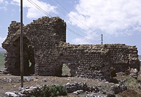
At a short distance to the south of the church are the walls of a rectangular building. This has been a well-built structure with a concrete core. There are clay pipes built into that core, perhaps indicating that it was a bathhouse. Clay pipes are also visible within some wall fragments at the eastern end of the main part of the plateau: they seem to have been part of a system of water distribution leading to the citadel. There are the foundations of more buildings to the north of the church. All these structures, and the church, may have been part of a monastery.
|
|