Background
Caravanserais (also known as hans) were commercial structures. They were stopping-places intended for the rest and security of caravans. They provided sleeping quarters for merchants and travellers, stables for their pack animals, and storage space for their goods. Within towns, a caravanserai could also act as a storehouse, or even as a market.
Caravans could be extremely large - as an example, Michael the Syrian mentions the death of 500 Persian merchants in a snowstorm in 1135. Caravans of this size were necessary in order to ensure their protection against robbery. However, no village would have been large enough to provide shelter and provisions for such caravans. For this reason, caravanserais began to be built from the 12th century onwards. Theoretically, their distribution should be every 20 or 30km (the normal daily stage of a caravan of camels) along the main routes.
Most caravanserais in eastern Anatolia were founded during two relatively stable and peaceful periods: in the 13th and 14th century when most of eastern Anatolia (including the city of Ani) was under Mongolian rule, and in the 17th and 18th century when the Ottoman and Persian powers were at peace.
Location
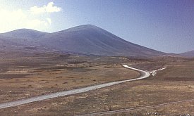
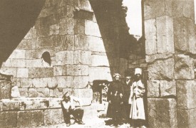
The building known as the "caravanserai of Zor" is located about 35km southwest of the town of Igdir, and at an altitude of about 1750 metres on the range of hills west of Ararat. "Zor" was the name given to it by the archaeologist Loris-Kalantar who, in 1913 (or 1912?), was the first person to study it. However, the village of Zor is actually more than 15km to the east of the caravanserai, in another valley.
The caravanserai lies beside a road that crosses the hills that separate the Arax valley from that of the upper Euphrates ¹. This route (which goes over the Koçak Pass at 2300 metres) is easier than the modern route from Doğubayazit to Iğdir (over the Çengel Pass) because the overall gradient is never steep.
The main international caravan routes through northern Armenia in medieval times ran in an east-west direction. The most important route came from Iran, via Tabriz, and then ran either south of the Ararat chain along the upper Euphrates (Murat) valley, or north of the Ararat chain along the Aras valley, before continuing towards Erzurum. Constantinople was the final destination for most of the trade that went through Erzurum. From Erzurum the caravans would travel onward to the Byzantine city of Trebizond, on the Black Sea, where the merchandise would be loaded onto boats and sent to Constantinople. An alternative route from Erzurum was to continue further west, to Erzincan, and then to Sivas from where the Black Sea was reached at Sinop or Samsun. Trade went mostly east to west, but some went the opposite way. There was also a substantial north to south trade in furs, honey, and slaves from southern Russia - most of this went through Trebizond.
The Zor caravanserai probably served a route to Ani that diverged off from the main Tabriz to Erzurum route. It was probably also linked with trade routes coming from the south, from the Lake Van region. Since a caravan would normally travel between 20 to 30km a day, the now abandoned town of Surmeli (also called Karakale) may have been the next convenient stop on the way to Ani, either the towns of Bagaran or Mren (both of which are also now abandoned sites) could have been the stop after that. From Ani, other routes would have led into Georgia and over the Pontic Mountains to the shores of the Black Sea. It is interesting that it was this route, via Ani, rather than the Erzurum route, that was chosen in the 1270s by the Nestorian priests Rabban Sawma and Markos.
General Description
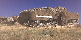
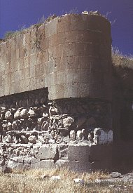
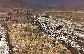
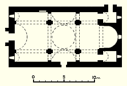
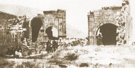
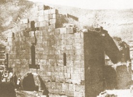
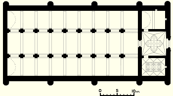
The caravanserai is a rectangular building, approximately 53 metres long by 25 metres wide. It is orientated approximately east-west. There is a single entrance in the middle of the east façade. There are no windows in any of the external walls, and the north and south walls each have a row of five, solid, semicircular towers. These may have had a defensive function, but also serve to buttress the wall. The outer walls have a thickness of between 1.5 and 1.65 metres, and have an outer and an inner facing of well cut, creamy-orange coloured, tufa stone, and a concrete core. All parts of the caravanserai seem to have been constructed at the same time, and there are no traces of later repairs or additions.
The caravanserai's internal structure consists of two zones. The eastern zone contains the entrance portal and three rooms: a square hall with smaller rooms to the north and south of it. The western zone, which takes up most of the building, contains three long aisles separated by two arcades of arches on pillars ². The Entrance Portal
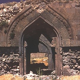
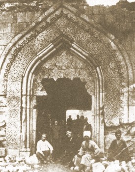
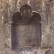
The entrance was highly ornate. The doorway would have been rectangular, but most of its lintel has been destroyed, as has most of the lancet shaped tympanum that once surmounted it. The Eastern Chambers
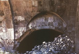
Behind the entrance doorway is a square room. In its west wall, directly opposite the entrance, there is another doorway. It is also rectangular and with a lancet shaped tympanum; however, this time it is plain and has a flat-arch lintel constructed from wedge-shaped voussoirs. This is the entrance to the western section of the caravanserai.
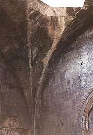
The roof of the entrance hall is higher that that of the adjoining chambers. This height is expressed visually on the external façade. The roof consists of a sort of star-shaped vault that holds up a flat, cross-shaped, ceiling. Externally, the roof is flat, and was probably once covered with a layer of earth and turf. A large part of the cross-shaped ceiling has fallen, and Thierry interprets the resulting gap as evidence of there being a skylight. However there is no trace of any edge of such an opening, and the flat ceiling would not have been structurally strong enough to support a lantern.
Small doors in the north and south walls of the entrance hall lead into supplementary rooms. There are the remains of a staircase in the north wall of the entrance hall. It leads up to the flat roof over the northern room.
The northern room, 7 metres by 5.3 metres, has a semicircular barrel-vault reinforced by a ribbed arch that rests on imposts. There are two small cupboards niches inserted into its walls.
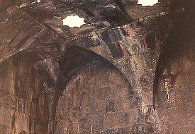
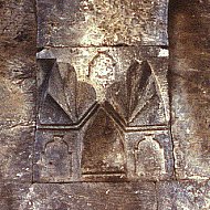
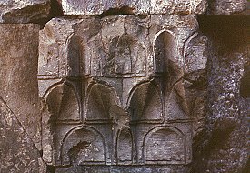
The southern room, which has similar measurements, has a more complex roof. From the quality of the decoration on this roof, Thierry proposed that it had a more prestigious function, perhaps serving as an oratory or a resting chamber for important travellers. The roof is composed of a series of groin vaults that hold up a flat, rectangular ceiling. This ceiling, now partially collapsed, was divided into six square compartments. In the middle of each compartment was a marquetry decoration; those that survive are either 8-lobed rosettes or 8-point stars. Some of the marquetry stones are missing, leaving gaps in the ceiling. Thierry misinterprets the openings left by the missing stones as oculus skylight openings. The vaults of the ceiling rest on imposts decorated with some stalactite (muqarnas) carving. In the north wall is a cupboard niche with a trefoil moulding at the top.
The Western Zone
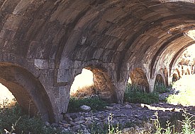
The western part of the caravanserai contained the stables and the main sleeping areas. It consists of three parallel aisles that are separated by two arcades of arches. The central aisle (at 7.5 metres) is wider than the side-aisles (at 5.25 metres).
A barrel vault still covers most of the northern side-aisle. Only parts of the vault over the southern side-aisle survive. The vaults are divided into bays using transverse ribs. The vault over the westernmost bay of each side-aisle is higher than the rest.
Nothing remains of the roof over the central aisle. However, it was probably a vault with a basket or segmental profile (rather than a full semicircle), and it probably had roof-lights. There seems to have been no roof lights in the side-aisles, so the whole interior would have been very dark. The vault over the cental aisle was also divided into bays using transverse ribs. These ribs rest on imposts decorated with stalactite (muqarnas) carving. Externally, the roofs over the side-aisles appear to have been flat. The roof over the central aisle was probably pitched.
Probably, when the caravanserai was in use, the central aisle would have been for animals, and would have been at a slightly lower level than the side-aisles, which would have been for people. There is now at least a metre of soil and debris piled over the original floor levels.
The eastern-most arch of each arcade is wider and taller than the rest, suggesting that they were intended to be entrances to the side-aisles. This implies that there was some sort of physical barrier separating the rest of the side-aisles from the central aisle. This barrier was probably a low wall that ran beneath each arch - such a barrier still survives in the 13th century caravanserai of Selim, now in Armenia.
Who Built The Caravanserai, And When?
The only surviving inscription of any age is a 19th century Russian one: it is a piece of graffiti, dated 1845, carved on the south aisle. Loris-Kalantar noted an inscription in Arabic that said "Constructed by Ashot". This inscription, which was carved on the ceiling of the southern room, has now been lost. The briefness of its wording suggests that this Ashot was perhaps the master mason who built the caravanserai, and his name suggests that he was an Armenian. Ünal noted the presence of masons' marks on the walls of the caravanserai.
Thierry believed the caravanserai to have been a Mongolian foundation, but built by an Armenian architect. He dates it to not earlier than the third decade of the 13th century and not later than the beginning of the 14th century. Rogers dated the caravanserai to a slightly earlier period, to that of the Zakarid rulers of Ani. Since the Zakarids also controlled the territory on which the caravanserai was build, they would have commissioned its construction. Ünal believed the caravanserai to be a Seljuk foundation. However, since the Seljuks did not control this region at that time, his hypothesis is wrong.
REFERENCES:
Kalantar, Ashkharbek, (Karakhanian, G., ed., Gurxzadyan, V. G., trans.), Armenia from the Stone Age to the Middle Ages, pages 73-74. Paris, 1994. Rogers, J. M., The Mxargrdzelis between East and West in Bedi Kartlisa, volume 34, 1976, pages 315-326. Thierry, Jean-Michel, A Propos de Quelques Monuments Chrétiens du Vilayet de Kars (IV) in Revue des Études Arméniennes, volume 19, 1985, pages 293-307. Ünal, R. H., Iğdir yakmlannda bir selçuklu kervansarayi ve Doğubayazit-Batum kervan yolu hakkmda notlar (Notes on a caravan route from Doğubayazit to Batum and a Seljuk caravanserai near Iğdir), in Sanat Tarihi Yilliği, volume 3, pages 7-15. Istanbul, 1970.
NOTES: |
|
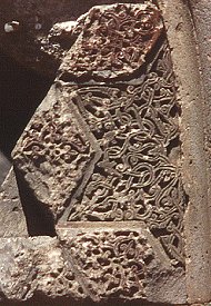
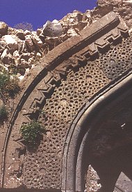
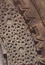
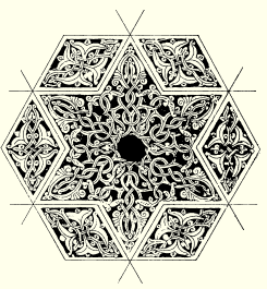 The surviving fragments of the tympanum reveal that it had a marquetry decoration comprising 6-point stars of grey-coloured stone and lozenges of reddish-coloured stone. The reddish colour is a stain, and not the stone's natural colour. Both the stars and the lozenges were covered in a rich foliated decoration of leaves and tendrils. The drawing opposite, from Ünal, shows a reconstruction of a section of the marquetry. The doorway and the tympanum are surrounded by three rows of beaded moulding. Outside that there is a wide band containing a complex interlaced carving of 12-point and 8-point stars. This interlace is framed by a zigzagging band consisting of alternately rectangular and v-shaped notches, similar to that on the narthex of the 13th century