


The monument known as the Taylar church is, using dirt tracks, about a 10km walking distance from the northern city walls of Ani and about a 5km walking distance from Horomos monastery. The walls and churches of Ani are visible from the site; of Horomos only its triumphal arch is visible. The site can also be driven to using a dirt track leading off the asphalted Essenkent to Jrapi dam road [note 1]. The nearest inhabited settlement is Haikadzor on the Armenian side of the border [note 2]
The church is located at the edge of a plateau above the gorge of the Akhurian / Arpa River that forms the border between the modern countries of Turkey and Armenia. The church is inside an abandoned settlement site that occupies a narrow and defensible peninsula created by a u-shaped bend in the river. The whole site is in the Turkish military's restricted border zone and access is, officially, not possible without obtaining permission.
Taylar in Past Accounts
The Taylar church has no surviving foundation or dedicatory inscriptions. Nothing is known of its history. Its original name is lost. Its current name is not mentioned in any known medieval source.
Its first known modern-era mention is a passing one in a description of Ani from the 1840s by Eugène Boré [note 3]. A photograph of the church, by Nahapetian, is reproduced in Josef Strzygowski's 1918 Die Baukunst der Armenier und Europa and described as the church at "Tailar" [note 4]. At least two photographs exist of the church by Toros Toramanian, and there is a short paragraph on the Taylar church in Toramanian's Material for the History of Armenian Architecture [note 5]. There is also a watercolour painting of the church by Arshak Fetvadjian. The first detailed study of the church was by Jean-Michel Thierry, published in 1983 [note 6]. The church is also mentioned in the World Monuments Fund's 2014 report Ani in Context [note 7], and there is a 2014 Turkish study by Güner Sağır [note 8].
Thierry wrote that the church got its name from a nearby village called Taylar, which at the time of his visit was called "Kizil Ay". There is no Kizil Ay on recent Kars regional maps, or on any map I have seen. There is a "Daylap" on the Turkish 1:200,000 contour map of Kars from 1953 [note 9]. However, there is now no village at its location - it is just an animal pen and a modern hut beside the dirt track from Ani to Taylar and no indication of a fixed settlement having ever been there. "Daylap" was probably just a seasonal encampment site. If this is correct, it is more reasonable for the encampment to have taken its name from the nearby church site rather than the other way round.
A comparison between the Nahapetian photograph and those by Thierry reveals significant additional damage to the church. More recent photographs show further damage and, because of the amount of masonry loss at the lower parts of the structure, the Taylar church is now at severe risk of complete collapse.
The Settlement Around The Church
What appears to be a barrier wall cuts across the northern end of the peninsula site. It has a length of about 130 metres and there is a gap near its eastern end than may mark the location of a gateway. This wall is now just a low, linear, mound of rubble and there is no cut masonry visible within its remains. Unless its upper parts were constructed of mud brick or timber, or a lot of masonry has been removed from the site, there does not appear to be enough material to have formed a wall of substantial height.
Behind this wall is a quite densely filled settlement site. Visible foundations indicate a large number of rectangular structures. One structure is composed of large boulders and may have been a linseed-oil press. The number of buildings are too numerous to be a monastery, and there is nothing monastic about their layout. Foundations also indicate a scattering of buildings extended northward beyond the limit of the wall.
At the northeast end of the site, just outside the barrier wall, a track zigzags down the side of the gorge to the river bank. There is an equivalent track on the other side of the river, opposite the southern end of the site. There must have been a ford that crossed the river here, probably leading to medieval Haykadzor.
The Exterior of the Taylar Church
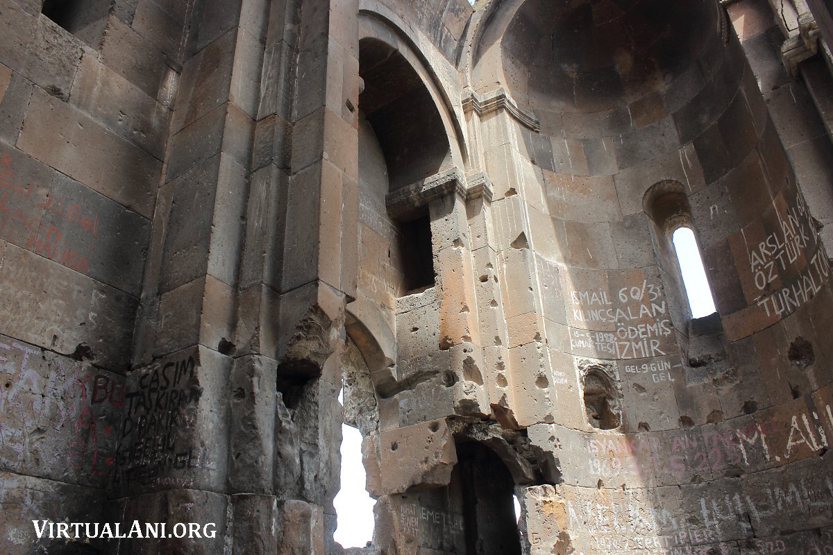
The church has a single entrance, located on its south side. A tympanum over this entrance has a sundial carved on its surface but is otherwise plain. A similar sundial, though more elaborately carved, existed over the south entrance to the lantern-domed hall at Horomos. Around the tympanum is an archivolt that probably rested on attached columns that once flanked a rectangular entrance opening.
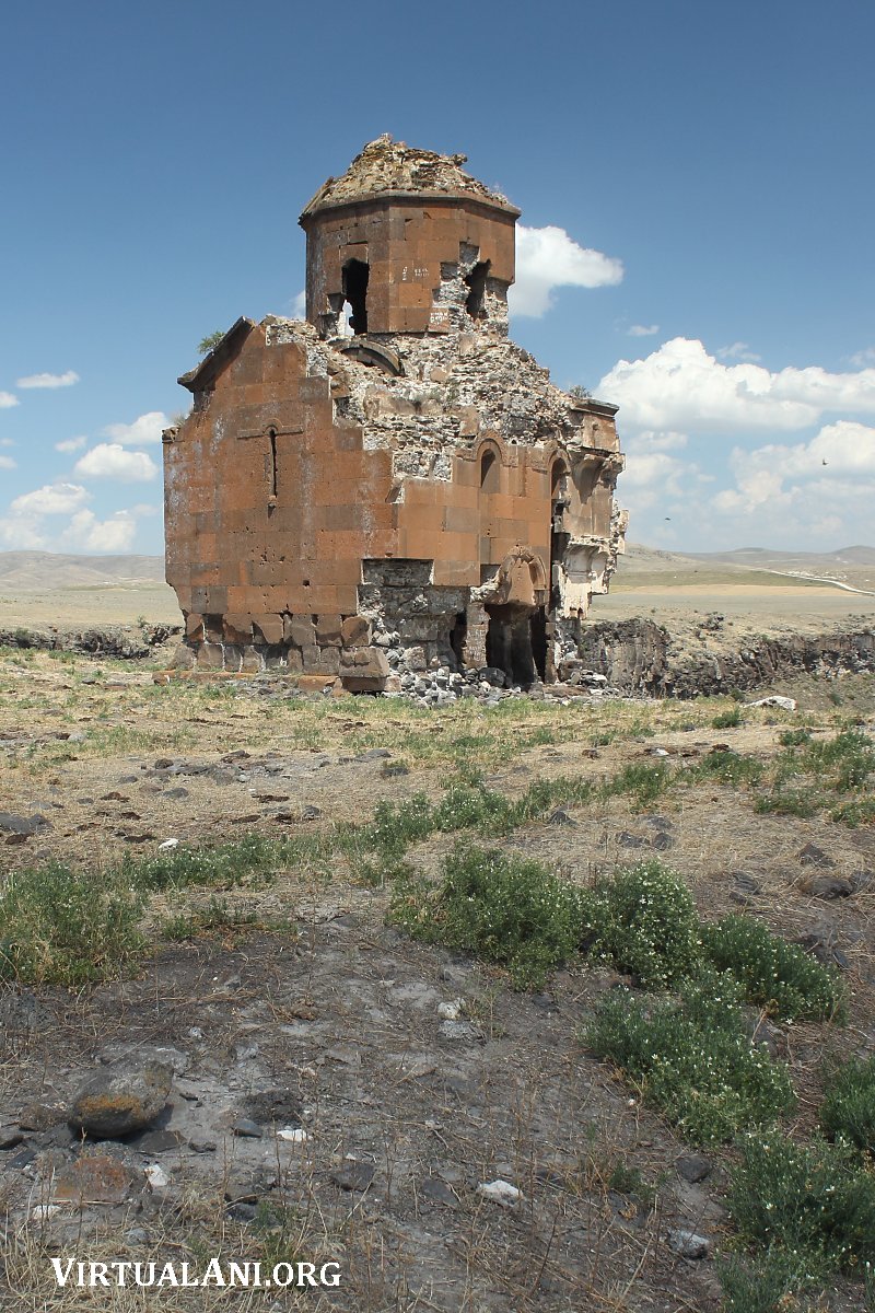
Above the archivolt is a single narrow window that had a hooded moulding, now lost. Above the hooded moulding was a relief carving, also now lost. The carving is visible in the Nahapetian and Toramanian photographs and appears to consist of two lions facing each other. There also appears to be a smaller third figure, maybe an animal, maybe a human on horseback, between the two lions. Thierry postulated the composition represented the Biblical Daniel in the lions' den; however, the posture of the lions (each has a raised head and outstretched front paws) is not consistent with the conventional typology of such depictions. A window on the north facade matches the one on the south, and there is a similarly sized window located centrally on the west facade; it has a plain hooded moulding.
The north, south, and east facades each have two v-shaped niches with conch-shaped semicircular tops that are surmounted by hooded mouldings. On the east facade, one of these hooded mouldings has traces of an incised and painted decoration composed of concentric circles probably an incomplete laying-out for a carving that, when completed, would have resembled the chain of intersecting circles on the hooded moulding over the apse window on the east facade. Also on the east facade were four small windows belonging to corner chambers. Only one of these windows survives above it is a hooded moulding decorated with plain circles, and above that is a rectangular panel containing an interlace that is similar to that found on the roof cornice. Linking this panel to the hooded moulding are two cylindrical mouldings resembling turned wood.
The east side of the church is at the edge of a steep slope that ends in near vertical cliffs. There is nothing obvious immediately west of the church that would have required this confinement. Perhaps there was a land ownership issue to the west of the church that restricted its location. Such a space restriction may also be the reason for the lack of a west entrance.
The church's pitched roof would probably have been clad with stone slabs they have all gone, as has most of the roof's cornice. Surviving cornice fragments carry an interlace decoration composed of six strands; on the surviving section on the east facade it is composed of only four strands, crudely laid out, suggesting that this part of the cornice may be a later repair.
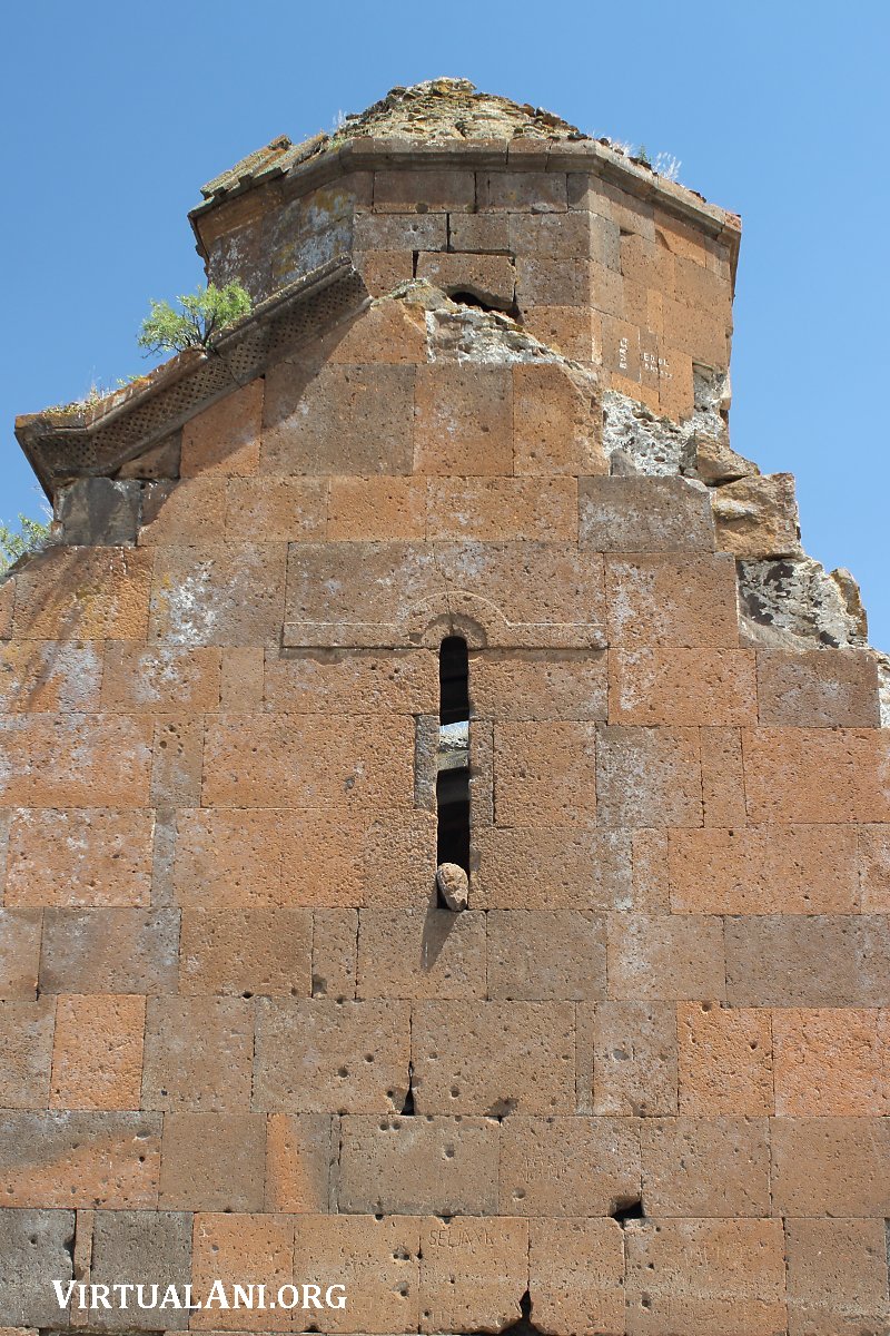
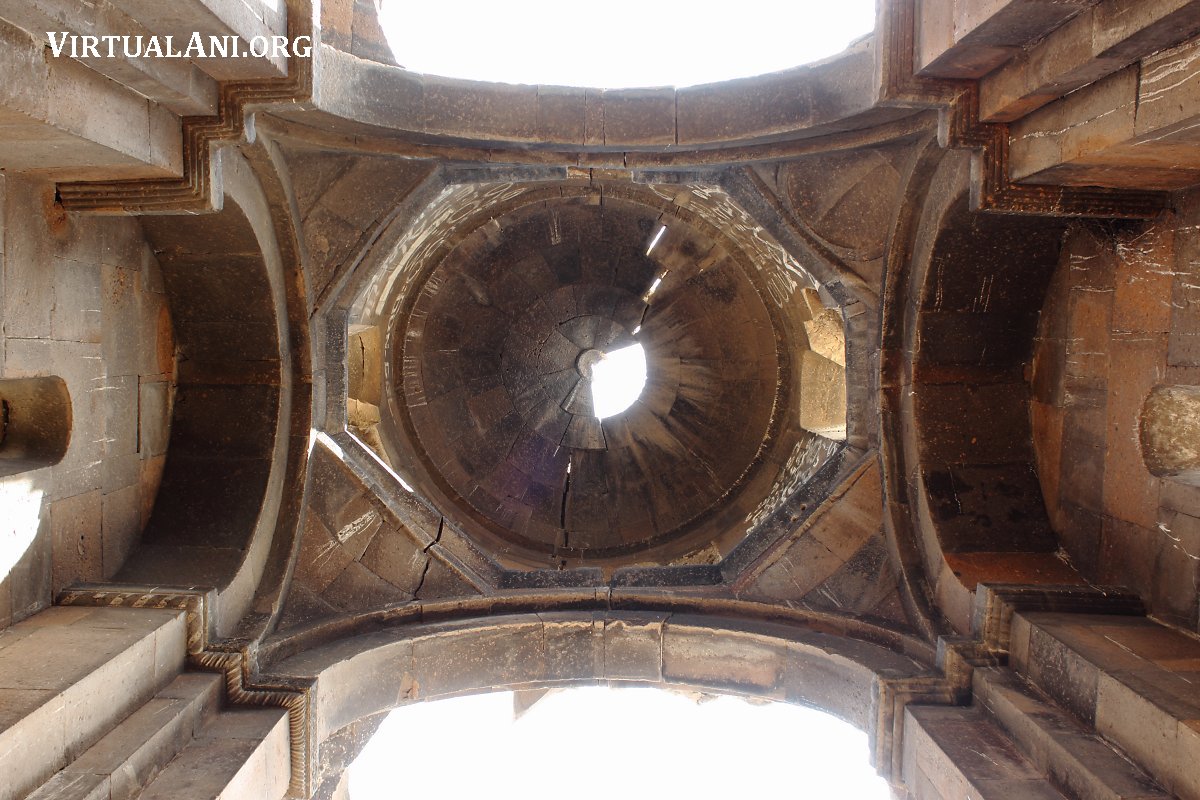
The exterior of the drum of the dome is octagonal and its interior is an oval cylinder. The interior of the drum is wider across its narrow side than the bay below, and the wall thickness of the drum is much less on its west side than on its north, south, and east sides. The result is that the exterior of the drum is offset to the east in relation to its interior. This could be to make the east and west sides of the drum align better with the v-niches in the north and south facades. The drum is pieced on its cardinal sides by four small windows that are plain on the exterior. The roof over the dome is an eight-sided pyramid with quite a steep slope; only a small section of its stone cladding survives. The cornice between the octagonal drum and the pyramid roof has a stepped shape and is plain and narrow. Some of the cornice has traces of layout lines for a row of concentric circles that were never carved.
The Interior of the Taylar Church
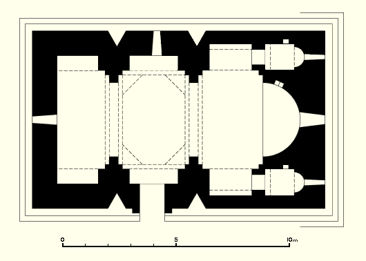
The interior of the church has a three-bay "domed hall" design (see the section below for a detailed explanation of this architectural type). Very unusually, the central bay is not a square but a rectangle. Above this rectangular bay is an oval dome supported on an oval drum; again very unusual since most drums are either cylindrical or octagonal. A plain cornice articulates the transition between the drum and dome. Part of the apex of the dome has collapsed and there is a crack running north-south through the entire dome and drum.

The transition from the rectangular central bay of the nave to the curved base of the dome's drum uses flat pendentives. Although some sources describe them as squinches, they are pendentives in form. The southwest pendentive has a scalloped shape; the rest have plain surfaces. Toramanian postulated that the southwest pendentive was a later addition. Sağır postulates the reverse, that the three plain ones are later repairs and the scalloped on is the surviving original. I see no evidence to support either of these assertions: all four pendentives appear to be from the same period and they, and the surrounding masonry, reveal no traces of a later reconstruction.
The piers under the dome have capitals; the northeast one is decorated with a row of circles containing six-petal rosettes, the other three capitals are plain.
In most domed-hall designs the v-niches on the exterior are in line with piers on the interior, but in the Taylar church thay are not. Perhaps the architect thought he would overly weaken the piers by inserting niches into their thickness through their centre line. Whatever the reason, it has led to various design workarounds in other parts of the church. For example, the windows onto the central bay are off-axis in relation to the piers and dome. This is so they can be aligned on the exterior exactly between the v-niches. The variation in the thickness of the drum mentioned earlier is probably another workaround, intended to align the exterior vertical axis of the drum to a centre line between the niches. Strangely, the entrance doorway has been left obviously off-axis in relation to the v-niches, perhaps indicating a design requirement that anyone entering the church should find themselves directly under the dome.
Part of the nave of the church retains its original stone slab paving, but the paving inside the apse has all gone and it is now unclear by how much the apse floor (or bema) was elevated in relation to the nave. A niche cut into the north side of the apse is located high up, suggesting a substantial height for the bema, but the cut stone facing of the apse continues down to the floor level of the nave, suggesting a low floor level to the apse. It may be that the niche is a later addition, added when the original bema was raised in height.
The vault of the apse has a slight horseshoe shape, with a cornice at the base on each side. The base of the barrel vault to the left of the apse rests on a cornice decorated with a row of concentric circles, the one on the right is similar but its decoration (like much of the decoration on this church) has not been completed beyond the stage of horizontal layout lines.
On each side of the apse are chambers on two levels. Each chamber has an east-facing apse with a window to the exterior, so it is appropriate to call them small chapels [note 10]. The lower level chambers have a doorway opening onto the east bay of the nave; the upper levels also have an opening onto the same bay, but located high up and with no fixed way to access it. The south wall of both the south chambers has entirely collapsed. Only the lower north chamber preserves its window opening on the exterior.
The letter "Ռ" ("R" in Armenian) appears in locations throughout the church. For example, on the exterior it is carved twice on the east facade, on the third masonry course above the stepped base, and on the interior it is found below the apse window, on the dome's northeast pier, and on the north wall of the central bay. They do not seem numerous enough to be mason's marks; perhaps it is the initial of the architect or mason. This letter can also represent the number 1000.
Domed-Hall Armenian Churches
The Taylar church has a domed hall design. The "domed hall", the English-language rendering of the term coined by Strzygowski as "kupell-halle", is an architectural form specific to early-Christian and medieval Armenian architecture. It is a hybrid of basilica churches and domed centralised churches, combining the elongated interior and east-west axis of the former with the verticality of the latter.
Domed halls have a rectangular nave, without side aisles, divided into three bays and ending with an apse. The central bay is usually square in plan, above which is a dome resting on a drum. The transition from the square bay to the circular or octagonal drum is accomplished using either squinches or pendentives. The supports for the drum and dome are four solid piers that are joined visually and structurally to the north and south walls of the church. The protrusion of the piers from those walls creates three shallow niches along each side of the nave, expanding the volume of the church while maintaining an open interior space and a rectangular exterior plan. The domed hall form may have arisen from a liturgical desire to have a large unbroken interior space in front of the altar. Domed centralised designs have the unbroken space, but have structural implications that limit their maximum size.
Domed hall churches emerged in early-Christian Armenian architecture in the late 6th century. Of the early examples, termed "archaic domed halls", the earliest accurately dated is the church at Aruch, started around 667-668 and completed around 671-672. Another notable example is the church at Ptughni, which has been variously dated to the late 6th century, the early 7th century, or the mid 7th century [note 11]. These early domed hall churches are much larger than those found in medieval Armenia when the domed-hall form became very common. In addition, as the domed-hall form evolved in the late 10th century, there was a tendency for the eastern bay to become smaller and smaller, and in some examples to disappear completely.
Church construction in Armenia all but ceased after the devastations and loss of autonomy caused by the Muslim Arab invasions. When construction gradually resumed in the 9th century, domed-hall designs reappeared. In the Ani region the earliest known example is the cathedral church at Shirakawan (dating from the late 890s). It is very similar to archaic domed halls in size and window layout - however, innovations include v-shaped niches on the north and south facades that cut into the mass of the attached piers that support the dome. The domed-hall church at Argina, dating from around 973, is smaller in size, has less windows, and has new features such as faceting of the piers and the addition of attached piers at the western end of the interior - features that foreshadow the Ani cathedral (Trdat, the architect of the Ani cathedral, may also have designed Argina). The domed hall St. Minas and St. George churches at Horomos monastery are even more compact, with design features that would become typical for 11th century monastic domed-hall churches.
The Date of the Taylar Church
The Taylar church has features found in archaic domed halls such as its eastern and western bays being almost equal size - as well as having architectural forms common in Armenian churches from the pre-Arab conquests period (such as the octagonal drum). However, it is much smaller than archaic domed hall churches and has innovations - such as exterior niches on the north and south facades - that are not found in archaic domed halls.
Various researchers have dated the church to the 10th century, more specifically to the mid 10th century. However, I think an early 10th century date is more likely: the positioning of the v-niches within the north and south facades indicates a tentative exploration of new forms and the cautiousness exhibited by not positioning them along the midline of the interior piers suggests a lack of existing examples.
A number of researchers have called the Taylar church a monastic church. Thierry suggested it may be Dprevank, a monastery known to have existed near Ani but whose location is yet to be identified. However, the surface remains suggest that the settlement beside the Taylar church was not a monastic one, and there is no physical evidence that the church formed a separate monastic zone within the settlement. Was it actually a congregational church built for a small town? Does the Taylar church, and the nearby large church at Oğuzlu, point to a number of small towns existing in the vicinity of Ani before Ani developed into a city, towns whose importance and size declined after Ani become the region's pre-eminent urban settlement. A scattering of such pre-existing urban populations close to Ani would help explain Ani's very rapid growth at the end of the 10th century.
NOTES:
1. The track from the Essenkent to Jrapi dam road appears to be the access route to Taylar used by those having permission Thierry, Sağır, and the WMF "Ani in Context" participants all took this route. The dirt track from Ani is not drivable by a normal car. For about half of the journey it passes through cultivated fields. Just beyond the cultivated zone an army sentry post is positioned at the fork in the track that leads to Horomos - however, it is not continually manned. From that point onwards the local sheep and cattle herders have been instructed to forbid visitors access. Soldiers in vehicles also patrol the border. In 2017 there were media reports that remote surveillance equipment was being installed along sections of Kars province's border with Armenia.
Near the Taylar site, just 0.5km away, are the remains of an abandoned Turkish military post whose crumbling buildings are now used as animal enclosures. A second Turkish military post, also abandoned, with a watch tower, is a little to the southeast of the first and overlooks Haikadzor. Both of these small military posts were abandoned in the 1990s in favour of a new and larger installation located beside the Jrapi dam, 3km north of Taylar.
2. Haikadzor was called Kizilkilise until 1950. In the 1890s H.F.B. Lynch described Kizilkilise as a settlement of some 120 houses "grouped around a stately church" - the red church from which it got its name (Armenia, Travels and Studies, 1901, volume 1, page 328). This church, dedicated to St Gregory the Illuminator, was, based on its dedicatory inscription, built between 980-985 by Sargis, abbot of Horomos, and his son and successor abbot at Horomos, Soghomon (Edda Vardanyan, ed., Horomos Monastery, Art and History, 2015, p31-34), and was designed by the "architect monk" Samehan (Zaven Sargysian, Armenia 1700 years of Christian Architecture, 2001, p110). It has a domed hall plan, but of the sort typical of the late 10th and early 11th century. A 13th century restoration remodelled its entrance.
The Kizilkilise of Lynch's time is no longer inhabited; at some point during the Soviet era the settlement was moved a little to the east and the old site became isolated within a restricted military zone along the border. If it were possible to go from Taylar to Haikadzor using the track down to the river and fording the river, the walking distance from the Taylar church to the St Gregory church would be about 3km.
3. Boré, Eugène; Aspect des ruines d'Ani, Le Correspondant. Paris, 15 March 1843.
4. Strzygowski, Josef; Die Baukunst der Armenier und Europa, Vienna, 1918, volume 1, page 208, illustration 245. In the book's introduction Strzygowski refers to the photographer as "Dr Nahapetian" and mentions that his work appeared in the photographic album Caucasian Views published by the Tiflis-based publisher Ermakov as well as being used to illustrate examples of Armenian architecture in Rivoira's 1914 Architettura musulmana. A number of Nahapetians photographs are in Strzygowski's book, including one of Mren cathedral. In the recent RAA article on Mren (in Vardzk (Duty of Soul), No. 7, 2012) that Mren photograph, and several others, are erroneously attributed to Ermakov.
As well as the Nahapetian photo, whose negative may be lost, there are (at least) two glass plates of Taylar in the archives of the National History Museum of Armenia, HMA Nº 5145 & 5146. Both are atttributed to Toros Toramanian. They are reproduced here as images 12 and 14, which are scans of the versions published in Mandelstam's Armenia. Photographs of Armenia 1878 1920 (in Russian), Yerevan, 2016. Thierry mentions a photograph of the north side of the Taylar church held in the archive of the École des hautes études in Paris. It is probably image 15 here (which was found on the internet, without attribution).
5. Toramanian, Toros; Material for the History of Armenian Architecture (in Armenian), Yerevan, 1948, volume 2, page 201. His analysis contains a number of questionable or inaccurate observations: he considered the dome to be a later addition, that the structure was originally a single-nave church without a dome, and that there was originally a west entrance, now blocked off. I can see no evidence for any of this in the actual structure.
The watercolour by Fetvadjian is in the collection of the National Gallery of Armenia, catalogue number 1587 (Arshak Fetvachian, Paintings Graphics - Collection of the National Gallery of Armenia, 2008, p87). It is undated but is probably from the 1905-08 period.
6. Thierry, Nicole & Jean-Michel; "L'Eglise de Taylar" in A propos des quelques monuments chretiens du vilayet de Kars III, Revue des Études Arméniennes, volume 17 (1983), pages 336-348.
7. Report titled Ani in Context Workshop, September 28 - October 5, 2013, Kars, Turkey, published by World Monuments Fund, 2014.
8. Sağır, Güner; Karsta Bir Ortaçağ Ermeni Kilisesi: Taylar Kilise, Turkish Studies, volume 9/10, 2014, pages 929-940. It has a new survey of the monument but does not go much beyond Thierry's work in its description and analysis except that Sağır sees evidence of a restoration / reconstruction, and of "serious repairs"; I saw no such evidence. Sağır considers the incomplete decoration on hooded mouldings as evidence of replaced / repaired masonry I see this as just uncompleted decoration, a not uncommon occurrence on Armenian churches.
9. Harta Genel Mudurlugu, sheet BXV. Interestingly, Haikadzor / Kizilkilise is named Haliler on this map, which is not too dissimilar to Taylar. Daylap does not appear on GSGS 4193 sheet B16 1:200,000 contour map of Kars from 1941. On it, Haikadzor / Kizilkilise is called Kiziltepe.
10. In some sources there is an automatic labelling of such corner chapels in Armenian churches as prothesis and diaconicon. A prothesis is, in the Eastern Orthodox Church, a chamber on the north side of the altar apse for a priest to perform the Liturgy of Preparation, the act of preparing the bread and wine for the Eucharist. A diaconicon, in the Eastern Orthodox Church, is a chamber on the south side of the altar apse where vestments, books, etc., used in the Divine Services of the church, are stored, and where the clergy wash their hands before serving the Divine Liturgy. However, for liturgical purposes, such chambers are usually directly linked to the altar apse via an arched opening. Some medieval-period Armenian churches do have these links (such as the church of Tigran Honents at Ani), but they are not common and the normal arrangement is for the corner chapels to have their doorways open onto a side nave or crossing arm or (as at Taylar) a side bay. This suggests these chambers may have had a different or an additional liturgical purpose and that the prothesis and diaconicon labels may not be appropriate. NB., there is an interesting graffiti line drawing of a multiple-domed Armenian church on the north wall of the upper level south chapel.
11. Christina Maranci, the most recent to write on the subject (in Vigilant Powers: Three Churches of Early Medieval Armenia, 2015), favours a date between the construction of the Mren cathedral, which she dates to ca. 638-641, and that of Aruch.
PAGE HISTORY:
21st March 2018 - This webpage is published.
26th September 2018 - Additional archival photograph added, some additional content, minor textual changes.