|
Structure: Marr-Orbeli site 117. Other designations: Virgin's Castle; Kiz Kalesi; Kuysiamrots; Kusanats; Surp Astvadzadzin; the church of Zak'aria; the church of Zak'are; the church of Kizkale. Kizkale
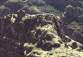
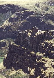
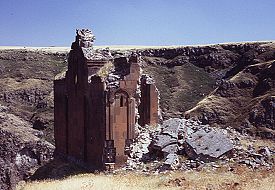
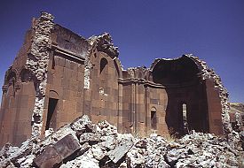
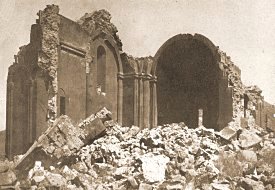
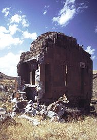
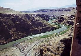
"It takes about two hours to walk here from the city walls, but it is a journey worth making. This is partly because of the views, which are stunning. Partly also because I think here - more than in any other part of Ani - you get a sense of the tens of thousands, hundreds of thousands, of people that once lived here. You know that they would have walked along the same path as you did to get up here; that they sweated over the same slopes, stumbled over the same boulders. And when they finally got up here they probably sat in the same spot as I am sitting, looking out over the same view, listening to the river in the gorge below, with the water flowing over the rocks and the birds singing in the bushes. And, for a while, the people who built this city seem very close." - Lines from the video "Journey Through Western Armenia" At the southern end of Ani, south of the citadel hill, the site narrows into a dramatic promontory that is almost encircled by the Arpa / Akhurian river and is protected by near vertical cliffs. The flat top of this promontory was once a separate fortified enclosure. This may have been one of the last parts of Ani to be abandoned because the foundations of the houses are better preserved here than in the rest of the city. This part of Ani is now known by the Turkish name Kizkale, the "Maiden's Castle". Its only known Armenian names have the same meaning: Kuysiamrots (Virgin's Castle) or Kusanats (Virgins' Castle).According to tradition, before Armenia's conversion to Christianity a pagan temple dedicated to the goddess Anahit stood here. This temple was destroyed by Saint Gregory the Illuminator, who then erected a church on the site. There is, however, no actual historical or archaeological evidence to substantiate this tradition, and it was probably an invention by the inhabitants of Ani to add prestige to their city. The Kizkale site has never been excavated; Artashes Vruyr humorously wrote that Marr chose to keep it in its virginal state. The summit can be reached by either one of two difficult paths that wind their way around each side of the promontory. The path along the side overlooking the Akhurian river was probably the original approach because it is guarded by a now ruined gateway.This part of Ani is now very rarely visited, even during the few years in the 1990s when the Turkish military allowed it. However, during the Russian period Kizkale must have been a popular spot for visitors - there is lots of Russian and Armenian graffiti on the church's walls. The panoramic vista from here back over the city is extremely impressive, as are the views along the river that forms the border between Turkey and the Republic of Armenia. The Kizkale Church
"In the time of the queen of queens T'amar, annointed by God and pious, I, shahanshah Zak'aria amirspasalar, her faithful servant, son of the great Sargis Mkhargrtzeli, by the will of God erected this monument ... in this monastery, close to the church built by our Illuminator, Saint Grigor."
- Part of an inscription on the walls of this church
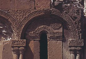
At the very edge of the precipitous cliff stands a ruined church, probably built during the first 15 years of the thirteenth century. The Zak'aria (also spelt Zak'are) that is mentioned in the above inscription was the governor of Ani on behalf of the Georgians from the year 1198/1199.
The historian Alishan, writing in 1881, gave the name of this church as Surp Astvadzadzin, the Holy Mother of God.
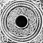
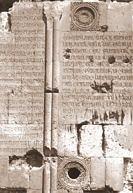
The dome and the whole of the south-western section of the church had collapsed by the end of the nineteenth century. In 1988 an earthquake destroyed the south-eastern corner of the church. Zak'aria's inscription, mentioned earlier, had been inscribed onto this section of the wall. Also on this part of the church there were two circular windows with ornate frames. The drawing, above left, is by Arshak Fetvadjian and depicts the lower circular window. (NB: under current Turkish army restrictions, visitors to Ani cannot visit the Kizkale peninsula. The peninsula also lies outside the wire-mesh fence that surrounds most of Ani.) |
|
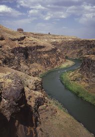
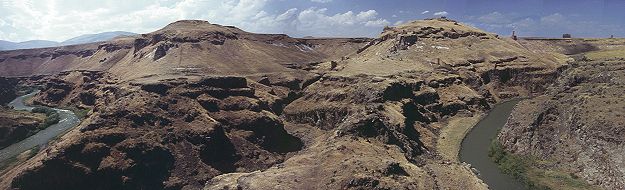 11. A panoramic view looking north from the Kizkale promontory - the Tsaghkotsadzor valley is in the middle |